Friday, January 22, 2016

RAKSHAN RIVER BALOCHISTAN

RAKSHAN RIVER


The Rakshan River rises at the Nidoki pass, south-west of Shireza, district Washuk, Balochistan Under the name of Nag, and running south-westward, it unites with the lop stream at a point to west of Nag-e-Kalat. It then flows west-south-west through the centre of the long valley comprising the Panjgur District, Makran, and parallel with the Siahan Range on the north and Zangi Lak hills on the south. In Rakshan it possesses little or no water, in Panjgur, however, it expands into a series of bright clear pools (kor joh) connected with each other by small water channels running over a pebbly bed. The banks are here bordered with numerous date palms and most of the water is used for irrigation. To the west of Kallag, the last village in Panjgur is Dabbag, where there are more pools and much long grass, tamarisk and kahur trees.

Tributaries

The only considerable tributaries joining the river west of Panjgur are the Mazan Dashtuk from the west, the Askani from the east, and the Gwargo from the south. After traversing Panjgur, the main stream turns northward and joins the Mashkel River from Kuhak on the Iranian side just south of the point where it bursts through the Koh-e-Sabz range by the Tank-e-Grawag or Grawag defile.

The Mashkel River crosses the Siahan Range at Tank-e-Zurrati and runs along the western side of Kharan to the Hamun-i-Mashkel, the total length from the source of the Rakshan being 258 miles.


Through a considerable water course, the banks of the Rakshan are low, shelving and irregular, consisting of hard clay known as kork in the Balochi language. In Panjgur the average depth is about 1/2 miles. It carries high floods, but owing to its breadth they never do much harm. The bed contains a little tamarisk or grass to relieve the monotony of the barren region which it traverses. Though the river is easy to cross, dangerous quicksands exist in some places.

Sixteenth-Century Dam

In the times of the Malik rulers in the 16th century the river is said to have been dammed by the large band close toBonistan village, the western part of Issai, the remains of which are still known as Band-e-Gillar.

DASHT RIVER BALOCHISTAN

DASHT RIVER

The Dasht River is located in the Makran region and Gwadar District, in the southwestern section of Balochistan Province, in southwestern Pakistan

Tributary
The Kech River is a seasonally-flowing eastern tributary of the Dasht River, with headwaters in Iran.

Mirani Dam


The Mirani Dam is located across the Dasht River The dam was built to supply agricultural irrigation water for the surrounding areas, flood control in the downstream region, and to provide drinking water for the city of Gwadar.


Friday, January 15, 2016

WATERFALL IN BALOCHISTAN


Stream and Rivers in Balochista

HUB  RIVER


Hub River is located in Lasbela ditrict, Balochistan. 
It forms the provincial boundary between Sindh and Balochistan. It covers an area of 32 square miles.

Hub River originates from the Pab Range in the south eastern  Balochistan and continues in Kirthar Range with the border of Sindh, reaches Hub and then falls into the Arabian sea.


HUB

HUB

Hub is the capital city of the Hub Tehsil, located in the Lasbela District in Balochistan. Its previous name was Hub Chowki. After the development of factories and many other industries, the town was renamed to Hub.

Hub is one of the largest industrial cities of Balochistan It is emerging as a commercial centre due to its proximity to Karachi. The Bazaars and markets are full with varieties of goods as well.

There are several ethnic groups living  in Hub including: Brahuis, Balochis, Muhajirs, Sindhis, Punjabis, Kashmiris, Seraikis, Pakhtuns, etc. The majority of the population is Muslim, while there is small Hindu and Christian minorities.

HUB  RIVER

Hub River is located in Lasbela ditrict, Balochistan. 


It forms the provincial boundary between Sindh and Balochistan,  It covers an area of 32 square miles.


Hub River originates from the Pab Range in the south eastern  Balochistan and continues in Kirthar Range with the border of Sindh, reaches Hub and then falls into the Arabian sea.

HISTORY
Oreitans were the ancient inhabitants of modern Lasbela District in Balochistan province of Pakistan. Alexander the Great crossed Hub River through Lasbela on his way back to Babylon after conquering Northwestern India. Alexander mentions the river name as Arabius, and local people as Oreitans
Muhammad bin Qasim crossed Hub River when he passed through Lasbela on his way to Sindh.

HUB DAM
Hub Dam is a reservoir on the Hub River. It is s the Pakistan's third largest dam. It is situated 56 km from Karachi. It is in the north of Karachi bordering the Kirthar National. 
Hub Dam is 15,640 meters (m) long of which 10,240 m lies in Sindh while rest in Balochistan.

The dam is extended to 24300 acres with gross storage capacity of 857000 acre feet. The dam is relatively shallow with maximum depth of 9.6 m.
Hub River separates the provinces Balochistan and Sindh, each of which receives water by a canal from Hub Dam reservoirIt is an important source that provides the drinking water to city Karachi

The dam was constructed in 1981 It is located  in a region of arid plains and low stony hills. Much of the shoreline is steeply shelving and stony, and there are many shallow bays and small islands.

The dam is situated in an area of semi arid and desert with sedimentary rocks.The upper catchment is sub – mountainous to hilly and plain. The area is generally barren with sparse vegetation at certain locations The climate of the area is predominantly arid
There are a few small islands in the midst of the reservoir.

The catchment of the Hub reservoir is wholly rain fed. The water level in the reservoir fluctuates widely according to rainfall in the water catchment area

The dam is an important staging and wintering area for an appreciable number of waterbirds and contains a variety of fish species which increase in abundance during periods of high water

HUB  DAM WILDLIFE  SANCTUARY
In 1974, area around Hub dam was declared as a wildlife sanctuary by the government of Sindh.to conserve waterbirds and the indigenous fish Mahsheer.Before the creation of the dam, this area was famous among anglers as the habitat of Mahaseer, a game fish


This sanctuary is about 27219 hectors in size. The eastern shore and area south of the Dam is in Sindh and are protected in the Kirthar National Park and Hub Dam Wildlife Sanctuary

FAUNA
Hub Dam Wildlife Sanctuary area has 16 species of mammals, 160 species of birds, 23 species of reptiles, 03 species of amphibians, 29 species of fishes, and 25 species of plants


The surrounding hills are the home of Urial, Sindh wild goat, Chinkara gazelle, Wolf, Jackal, Common fox, Pangolin and numerous other birds and reptiles.


It is favorable area for feeding and nesting for Cranes, Pelicans, Ducks and Waders. It is also an important habitat of migratory birds. There is plenty of waterfowl in the lake, both resident and migratory A Forest Plantation and Recreational Park has been established

Hub Dam is a also a tourist resort It is an ideal place for bird watching fishing. Swimming On weekend holidays a large number of peoples from Karachi visit there to enjoy picnic, swimming and fishing.
A rest house of WAPDA is also located there for tourists stay.

*-*-*-*-**-*----**-*-*--**-*-*-*-******-*-*-*-*-*-*-*-*-***-*


Thursday, January 14, 2016

ZiZri Valley (Ziarat)


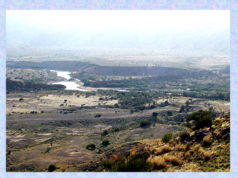
Zizri is one of the most beautiful valleys of Ziarat. This valley possesses a breathtaking beauty.The valley has very large and some of the oldest Juniper trees. It has untouched natural beauty which make it unique from other valleys of Ziarat.. 


Zizri valley at a distance of about 12 kms from Ziarat town. It  located at an elevation of 2,250 m above sea level. It is  situated on the southern edge of the Ziarat It is mostly mountainous area with thick juniper forest, wild flowers and many herb plants. 

Zezri valley is accessible from Ziarat. The route goes through Prospect Point . The drive from prospect point is quite picturesque and the road passes through a thick Juniper forest with occasional glimpses of the valleys down below.The road is shingle and  rough from Prospect Point to the Zizri valley.

The black top road from the Quaid -e -Azam Residency goes to Prospect Point. It turn off at Green Juniper Restaurant to descend into Trang Nala. Climbing up, attain the jeep road to Kili Sardaran, home of the chief of the Sarangzai clan of Kakars.Leaving the village to your right, enter the juniper-covered plateau of Bar Maghzi, at the far end of which the trail descends into the dry gorge of Loi Ghat. The barely visible trail climbs to Ismail Maghzi before leading to Orazhe Sar, the highest point, from where it is downhill all the way to Zizri. To the east is the sheersided 3,485 m cone of Khalifat, Passing the landmarks of the bleached white Spin (White) Maghzi and the knob of reddish brown rock called Tor Skhar (Black Rock), one attains the concrete pond of Gharrai beyond which lie the fields of Zezri. The fields and orchards of Zizri lie on a short walk away.
Zizri valley has significant importance because it lies in the base of Khalifat mountain. This mountain is the highest mountain of Ziarat and the second highest of Balochistan located in Suleiman mountain range. . Zizri is located on the north east side of Khalifat peak. Zizri valley provide leading route to khilafat peak.  The route from the valley goes into the forest along the eastern edge of the Khalifat peak. After crossing the forest,  towards  right direction one has to enter a narrow slide which ends in a sheer fall to the right and a rock wall to the left. 
The panorama view of this valley is so impressive.which make it a unique and distinctive. Juniper  trees found  in this valley are mostly straight and high with trunks measuring some six metres make it a  picturesque valley. The contrast of  yellowish rock,with  the green juniper trees that grow among the rocks and on the valley floor make it so amazing.  

The valley provides quiet and picturesque escape for nature lovers with high rocky walls dotted with Junipers surrounding .,There are many varieties of birds and the chirping sound of birds make it a perfect natural and pristine  place.The juniper forest ecosystem of zizri valley provides habitat for endangered wildlife species and supports a rich diversity of plant species There are found some wild species including Suleiman Markhor, Urial, Black Bear and Wolf.
                                            Green Domes  in Zizri valley
The aromatic ziziphora, used as a remedy for colds and influenza, is also abundant here, spread over the valley floor like a green carpet. Especially during the rainy season, the fragrance of this medicinal plant spread all over the valley be missed. There are also  wild olive,forest in this valley.

Development Authority of  the district government had constructed Huts which is for the purpose  if the weather gets too unbearable.than  to take refuge in  The  beautiful huts are unique with there conical designs with red roof. These  huts has surrounding lawn with children play area and with few swings. A constant aroma comes from the forest. It is a serene place surrounded with contrast of grey mountains and juniper tress. It is base and from here the Zizri valley and surrounding  forest can be explored. This place offers a spectacular view of the  mountainous area surrounded it Khalifat peak is seen from here 


The entire area of Zizri valley is worth visiting for its lush green natural beauty, its enchanting juniper forests with Some of the trees which are almost 4,000 to 7000 years old, mountain peaks,The area is refreshingly cool in summer  


Zizri valley with  the juniper  around offer good opportunity hiking and trekking. Camping is recommended to enjoy the nature
The Zizri valley is good for a day trip and for camping.
The best time to visit Zizri valley is between May to August  when the temperature is in comfortable ranges. It is refreshingly cool in summer,  It is extremely cold in winters and  gets a heavy snowfall.


The Spring season is in April The summer season is from May  to August. It starts getting cold in September and from November to March.it is winter.
******************************************