INTRODUCTION
Hingol National
Park is located
in Balochistan province of Pakistan. It is the largest National
Park in Pakistan. It covers an area of 1,650 square kilometers (640 sq mi).
HISTORICAL BACKGROUND
Hingol National
Park was established in 1988.Dhrun, Hingol and the area in between Rodani-Kacho
were declared as Hingol National Park.
GEOGRAPHY
Hingol National Park is located along the Makran coast. It lies within sections of Lasbela District, Gwadar District, and Awaran District. The Gulf of Oman of the Arabian Sea are to the south. Karachi is approximately 190 kilometers (120 mi) to the southeast on the coast.
TOPOGRAPHY
Hingol National Park is one of the unique and most beautiful places to be found in Balochistan, It contains a variety of topographical features and habitats, varying from arid subtropical forest in the north to arid mountain in the west. Large areas of the park are covered with drift sand and can be classified as coastal semi desert.
Hingol National Park is one of the unique and most beautiful places to be found in Balochistan, It contains a variety of topographical features and habitats, varying from arid subtropical forest in the north to arid mountain in the west. Large areas of the park are covered with drift sand and can be classified as coastal semi desert.
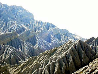
The park has high aesthetic venues and highly diverse ecosystem mixed landscape like beaches, sand dunes, rocks, mud volcanoes, clay mountain ranges, patches of agriculture, mountains, wetlands and the sea.
 |
| Newly constructed private rest house |
Approximately
5,000 households spread in more than 200 scattered villages in Hingol National
Park. Communities living inside and around the park have direct or
indirect dependency on it. The main sources of livelihood for local communities
are livestock, fishing, cultivation, wood cutting and hunting.
BOUNDRIES
OF HINGHOL NATIONAL PARK
NORTH BOUNDARY
EAST BOUNDARY
Eastern side of
the boundary starts from Babro Kaur and moves towards south on its
tributary coming from Garri Mountain. In the east of HNP boundary it extends southwards
following Awaran/ Lasbela district boundary, Garrai Kaur, Pachhri Kaur, Deokoh
Wyaro Kaur, Rayen Kaur, and passing through Manjwani Pass, Manjwani
Kaur and then a 5km buffer of Chander Gup volcano and enters in
sea
WEST BOUNDARY
In the west, boundary
passes through Gaz Ab Kaur, Manneji Kaur, Koh Sarri Kaur, Parkin Kaur and
junction of Solari Kaur and Hingol River. From this point it follows Hingol
River up to the junction of Pao River and Nul River which is the northwestern
corner of the Park.
MAKRAN COASTAL
HIGHWAY
The Makran
Coastal Highway (MCHW) passes though the southern side of this park and that
provides the travelers a great view of the mountains at the southern side and
sea view at the northern side Makran Coastal Highway passing through the HNP
provides beautiful landscape, wildlife and sea breeze.
BUZI MONUMENT
VALLEY
Buzi Monument
Valley is in the region of Hingol National Park lies on the Southern Coast
of Kech Makran. Traveling towars Gwadar on Makran Coastal
Highway and about 6 kms from Kund Malir, one would be struck with the beauty of
the natural rock formations Buzi pass is the gallery of beautiful artwork of the
nature
It is
characterized by a cluster of vast sand mud, sandstone foothill. Sand
dunes, which are basically ridges of sand created by the wind; found in the
deserts or near the oceans. The coast of Makran has muddy hills with very fast
winds blowing throughout the year. These fast winds cut through the muddy hills
and mountains and result in a natural rock formation with various shape.
The rock formation has few famous characters names, like "Princess of Hope". It looks like a princess standing with grace, wearing a royal robe and a hood.
Another famous shape called "Sphinx" (Lion) which looks like the
Great Sphinx of Giza and constructed on the order of the Pharaohs to depict the
pharaoh located in Egypt.
MUD VALCANOES
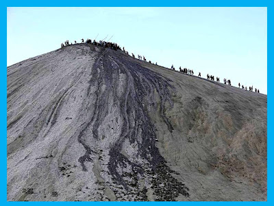
There are many active mud volcanoes located in Hingol. Approximately 20 locations are having clusters of mud volcanoes. Mostly these mud volcanoes are in the region which are situated in out-of-reach areas and is having very difficult terrain. These mud volcanoes are about a kilometer off the main Coastal Highway leading from Lasbela to Gwadar;
There are many active mud volcanoes located in Hingol. Approximately 20 locations are having clusters of mud volcanoes. Mostly these mud volcanoes are in the region which are situated in out-of-reach areas and is having very difficult terrain. These mud volcanoes are about a kilometer off the main Coastal Highway leading from Lasbela to Gwadar;
Chandragup mud
volcano is the largest and highest volcano in the world located in Jhao
tehsil a part of hinghol national park. It is located in the southeastern part
of the park. It is only 73 meter (273 feet) high and is 450 feet (137.16
m) in diameter. Khandewari another largest mud volcano is in the Haro range in
the eastside of a parkt
HINDUS SCARED PLACES
There are three
sacred places of Hindus in Highol national Park. Many Hindus visit these areas
each year. There names are a follow.
1.
Hinglaj Mata Mandar
2.
Chandragup Mud valcano
3.
Khandewari volcano
HINGLAJ
Hinglaj is a town on the Makran coast in the Lasbela district of Balochistan. Hinglaj is an important Hindu pilgrimage site also called 'Nani ki Haj' located in the center of Hingol National Park. It is situated near the peak of one of the mountains of the Makran Coastal Range. It is approximately 120 km from the Indus River Delta and 20 km from the Arabian Sea. The area is extremelyarid.
Hinglaj is a town on the Makran coast in the Lasbela district of Balochistan. Hinglaj is an important Hindu pilgrimage site also called 'Nani ki Haj' located in the center of Hingol National Park. It is situated near the peak of one of the mountains of the Makran Coastal Range. It is approximately 120 km from the Indus River Delta and 20 km from the Arabian Sea. The area is extremelyarid.
NANI MANDIR
The Hinglaj
area has the Nani Mandar, a sacred place for the Hindus. 109 km of the Coastal
Highway runs through the National park
Nani Mandir, also known as Hinglaj Mata, Hinglaj Devi, or Hingula Devi is a Hindu temple in Hinglaj, It is a form of Durga or Devi located in a mountain cavern on the banks of the Hingol River. The cave temple of Hinglaj Mata is located in a small natural cave in a narrow gorge in the remote, hilly area.
NATURAL WATER
Natural water bodies include river, water channels, oceanic water, small lakes and streams. In the area, secondary water channels are of non-perennial nature i.e. remains dry throughout the years except the rainy season.
HINGOL
RIVER
The Hingol River at the Hingol national park is stretched at 350 miles and is the longest river in Balochistan. The water is crystal–clear, reflecting the incredible blue of the sky. It forms the connection between mountains, coastal sand dune areas, estuary and the Arabian Sea
The Hingol River at the Hingol national park is stretched at 350 miles and is the longest river in Balochistan. The water is crystal–clear, reflecting the incredible blue of the sky. It forms the connection between mountains, coastal sand dune areas, estuary and the Arabian Sea
STREAMS
Hingol
National Park includes many streams and the estuary of the Hingol River. There
are plenty of streams flowing in the park.
Five streams flows from the North, others merge in Hinghol River from East and West. Ara Kaur, Duraski, Mashkay Kaur, Naal Kaur (main) flow from NorthBabro, Hodar, Kuli Kaur & Pacherri streams join Hingol from the East Aryan and Karpasi Kaur streams join from West Maar Kaur (also called Babro) is a tributary of Hungol RiverDid a jeep-cum-trekking trip from North (Tirranch, Awaran) to South in the Hungol National Park area.
Five streams flows from the North, others merge in Hinghol River from East and West. Ara Kaur, Duraski, Mashkay Kaur, Naal Kaur (main) flow from NorthBabro, Hodar, Kuli Kaur & Pacherri streams join Hingol from the East Aryan and Karpasi Kaur streams join from West Maar Kaur (also called Babro) is a tributary of Hungol RiverDid a jeep-cum-trekking trip from North (Tirranch, Awaran) to South in the Hungol National Park area.
Few streams and river names are mentioned below:
· Arra
Kaur
· Babro
Kaur
· Chigarrdi
Kaur
· Deokoh
Wyaro Kaur
· Drabi
Kaur
· Durraski
Kaur
· Gaddagar
Kaur
· Garri
Kaur
· Gaz
Ab Kaur
· Gorhad
Kaur
· Gorangatti
Kaur
· Gurab
Kaur
· Guzzyun
Kaur
· Haaryan
Kaur
· Highol
River
· Karpasi
Kaur
· Koh
Sarri Kaur
· Kohar
Kaur
· Machi
Kaur
· Mar
Kaur
· Manneji
Kaur
· Manjwani
Kaur
· Mashkay
Kaur
· Nal
River
· Nali
Kohar Kaur
· Nul
River
· Pachhri
Kaur
· Parkin
Kaur
· Pao
River
· Rayen
Kaur
· Shanndi
Kaur
· Sharan
Wali Kaur
· Solangi
Kaur
· Solari
Kaur
· Wadi
Kour
COASTAL PLAINS
A
coastal plain is an area of flat, low-lying land adjacent to a seacoast and
separated from the interior. Desert valleys with steep slope A large area of
HNP consists of sandy mountains.
KUND
MALIR BEACH
Kund
Malir is a desert beach , about 145 km from Zero-Point on Makran Coastal
Highway. The area is part of Hingol National Park. It is considered to be one
of the most beautiful beaches in this world.
ORMARA
BEACH
The
Ormara beach; is an old coastal city .Tt comes going towards Gwadar all the way
through Makran Coastal Highway
FAUNA
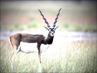
Several
species are found in the Hingol National Park At least 35 species of mammals,
65 species of amphibians and reptiles and 185 species of birds are known to be
found in park. The park has been an excellent habitat to wild animals including
ibexes, Urials and Chinkara, besides number of resident and migratory birds.
MAMMALS
· Sind leopard
· Indian fox
· Jungle cat
· Pakistan sand cat
· Striped hyena
· Golden jackal
· Sindh ibex
· Urial
· Chinkara
· Honey badger
· Indian pangolin
· long-eared hedgehog
· Indian crested porcupine
· Indian gray mongoose
· Cairo spiny mouse
· Carrot-tail viper gecko
BIRDS
· Houbara
bustard
· Spot-billed
pelican
· Dalmatian
pelican
· Bonelli's
eagle
· Imperial
eagle
· Golden
eagle
· Tawny
eagle
· Griffon
vulture
· Egyptian
vulture
· Cinereous
vulture
· Laggar
falcon
· Red-necked
falcon
· Kestrel
· Brown-necked
raven
· Lichtenstein's
sandgrouse
· Grey
partridge
· See-see
partridge
· Stone-curlew
· Indian
sandgrouse
· Crowned
sandgrouse
· Painted
sandgrouse
· Eurasian
stone-curlew
· Eagle
owl
· Sind
pied woodpecker
· Hume's
chat
· Long-billed
pipit
· Striped
buning
· Finch-larks
· Hoopoe
· Shrike
· Black
bittern
· Goliath
heron
· Black
ibis
· Wheatear
REPTILES
· Marsh
crocodile
· Olive
ridley
· Green
sea turtle
· Desert
monitor
· Yellow
monitor
· Indian
fringe-fingered lizard
AMPHIBIANS
· Skittering
frog
· Indus
Valley toad
FISH
· Golden
mahasheer
· Botchee
IMPORTANT
SPECIES
There
are 14 species of birds of special conservation interest on account of being threatened,
very rare or key species of the park.
1.
Sociable lapwing (critically
endangered)
2.
Saker falcon (endangered))
3.
White-backed vulture (vulnerable)
4.
Spot-billed pelican (vulnerable)
5.
Dalmatian pelican (vulnerable)
6.
Eastern imperial eagle (vulnerable)
7.
Pallas's fish eagle (vulnerable)
8.
Houbara bustard (vulnerable)
9.
Black ibis (near-threatened)
10.
Black-tailed
godwit(near-threatened)
11.
Sooty falcon (rare)
12.
Goliath heron (vagrant)
13.
Desert owl (confined to Makran
Coast only)
14.
Brown fish owl (very rare)
CLIMATE
The
climate of the area is moderate sub-tropical arid. Summer days are generally
very hot while due to sea moisture, temperature falls down in the nights. In
winter, season temperature varies day to night from 5 ºC to 35 ºC respectively.
An average annual rainfall of 50-150mm has been recorded.
It
is worth a place to visit to observe the diverse nature that has fantastic scenery of towering cliffs,
pinnacles and buttresses, the river winding between and pristine with clear water beaches.
*******************************************


