Washuk District is in the northwest of Balochistan, along Iranian border with Pakistan.The shape of district is approximately rectangular It Geographical Area is 33, 093 Sq, of which 71,520 hectares is arable. The rest consists mostly of barren desert and mountains of the Central Makran Range Shamsi air base is located in this district.
Washuk District was once part of Kharan District in Balochistan province. It was declared a separate district in 2007, but its governance issues are largely managed by Kharan’s district administration.
Washuk District is further subdivided into 3 tehsils or subdistricts, 10 union councils and 216 mauzas (villages).
The three tehsils are following:
Washuk
Mashkel
Basima
Washuk town is the district headquarters. Washuk, a small town, is situated at 464 kilometers to the south-west from Quetta, connected by shingle road with Surab on Quetta – Khuzdar section of RCD highway. It is also approachable via Nushki and Kharan. Washuk town is located at the center of the district. Mashkel is at the western corner and Basima at the eastern corner. Kharan, Chagai, Kalat, Khuzdar, Awaran and Panjgur are adjoining districts.Washuk town is at a distance of 195 km from Iran border. Washuk has both sandy and mountainous topography.The Shrine of Malik Deenar is at DHQ Washuk
MASHKEL TEHSIL:
Mashkel is a sandy area. Nausherwani tombs or Noshirwani tombs are located near Qila Ladgasht in Mashkel tehsil,Qila Ladgasht is small town located in Mashkel tehsil . The Nausherwani tombs are a set of nine tombs dating back nearly 800 years. Nikodar Ooghul belonged to the Arghun Dynasty and he converted to Islam and adopted the name Sultan Ahmad Khan
LIST OF VILLAGES IN MASHKEL DISTRICT
- ANALLO
- CHAKAR WAL
- CHALKI KEND
- CHARKI ROAD
- HOOKI
- JOOZ IZAT
- OOZ LAL KHAN
- JOZ E ABDULLAH
- KABGO
- KALAG
- KALLAGO
- KARAK
- KHURMAGAI
- KITGI
- KUMMI
- LADGASHT
- LOOTAK
- MARRIUM
- MASHRAQI ZAWAK
- MATTAN
- MOSHODI
- NAO TAGZ KHAND
- PASI KHAIR
- MOHAMMAD PASI SHER
- MOHAMMAD PHUL ABAD
- RAGOWAL
- RAJAB
- RAND MAKAN
- RAND NAZROI
- RAND PIR DIL KHAN
- SARAGEE
- SHAHIWALL
- SORRO
- TACHAPI
- TAGAZ KAND
- THULL
- TUCHAP
- AHOGOO
- ASKAN
- BARAKI
- CHAHOK
- CHAKUL DAD MOHAMMAD
- CHAHDAMDAM
- DAZI
- GADDUK
- GORAJ KALAG
- HOLE
- JODAR
- JOE SHAH SALEEM
- KAMAN RAOD
- KO E SIABAN
- KOSHKAN
- LAKAR
- MANJI
- MATHA
- MAZASAR
- NEELAN
- NOKCHAH
- PANYAM
- PATTKAN
- PUSHTI SHANG
- RAHI
- REGI
- SAQI CHAH
- SOHTGAN
- SORE REK
- SULTAN CHAH
- TANKZARATI
- TUMB
- YAKTA I
- ZAWAG
BASIMA TEHSIL:
Basima has mountains and granular plain. Tehseel Basima is moderately hot in summer and severely cold in winter. Dust storms also blow but their intensity is lower here. Precipitation is low. The soil of some areas is alluvial and extremely fertile. The best type is called "Matt". It requires less water and retains moisture for longer periods and is suitable for all crops
LIST OF VILLAGES IN BESIMA DISTRICT
- BESIMA
- BORRKO
- CHOT
- DALI
- DAMAG
- DURG
- FAQEER ABAD SAJID
- GAIDBAST
- JANGLE
- KORGI
- LOOCHO
- LOOP SAJID
- MOMAI
- RAZAK
- SAJID GEREEJ
- SIAHOZAI
- ZAYAK
- ZIARAT
- BAD RANG
- BALOCH ABAD
- BANSAR
- BARONT
- CHADD
- DAMBUN
- DHAN GATHRI
- DOLARI
- DUBNUMI
- GARARI
- GARARI -RAGAHI
- GORGAJE
- GOWARGAI
- HUSSAINZAI
- JHATT
- JO-E-GUL MOHAMMAD
- KAPAR
- KIRECHI
- KOCHA NAG
- LOPE
- NAG
- PARRA BIJJAR
- PASHTAKE
- PATTAK
- PIZAG
- SARAP
- SARLOP
- SHAMBNAL
- SHINGIR
- SHIRANZA
- SOLARE
- SUB-ZAB
- SUKHUN
- SUNG KALAT
- TANKI
- TARBAP
- AROUS
- DARAP
- GRESHA NO.1
- GURANDI
- HER-NAWAR
- JALAI
- KAMBAR
- MALHAN
- MURGO
- PALANTAK
- PEALIN
- SALGTAR
- BAGHDWAR
- BAKAT
- BANGAR
- DARG DAP
- GORHI
- GOWAR SHANK
- GREAHA NO.2
- KHARASI
- KHOI WAL
- KOH BUL
- KOH BUN
- KOTAGI
- KUMB
- LANDOO
- LUHRA
- MADAL
- MALHAN
- MAREY NAWAR
- MUSHKI
- SEERAG
- SHIMSHI
- SOLDAN
- SUGAP
- ZAIRKI
Major ethnic Group is Baloch. Nausherwanis are considered as the rulers of Washuk and most educated tribe in Washuk District. Languages spoken is Balochi, Brahvi and Urdu.
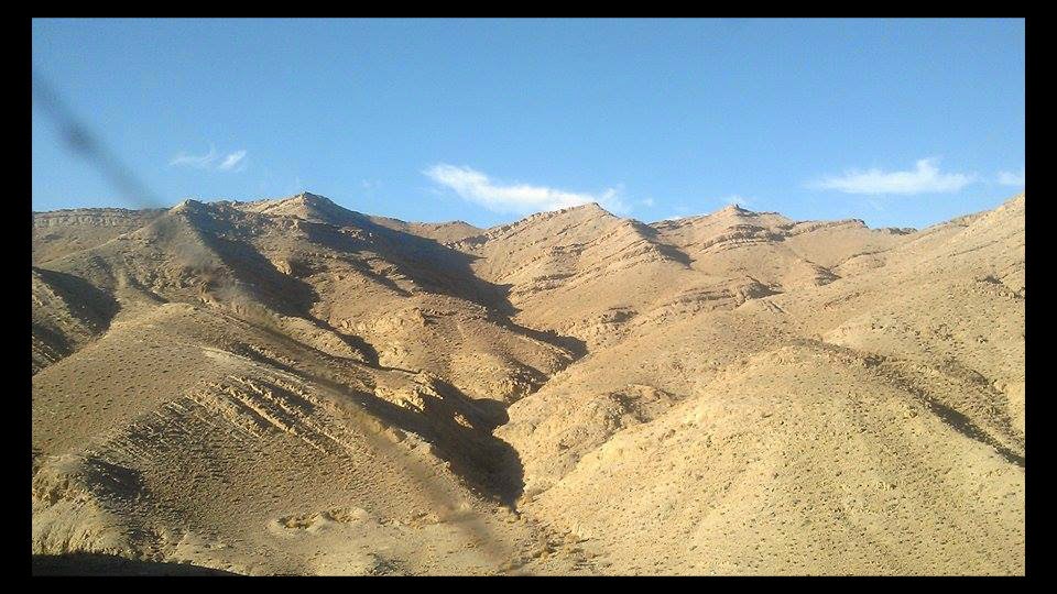
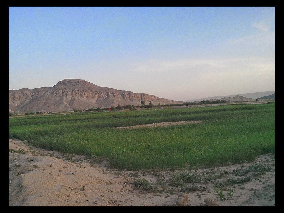
Geographically, Washuk district mainly consists of sandy, mountainous, and granular plain area. District Washuk is mountainous in the south bounded by Siahan Range, separating it from the Rakhshan valley and Panjgur District. Eastern mountainous region is known as Ras-Koh Range and separates Washuk from Gidar Surab, Rodenjo and Dasht-i-Goran valleys in Kalat and Besima in Awaran District.Kalporagan, Kaledin, Jaleq are populated Iranian towns located at west of this district.
The plain area, irregularly quadrilateral in shape is about 160 km in length and 40 to 60 km in width. It varies in elevation from 700 meters in the north-east to 492 meters in the south-west.
Washuk district 's area mostly comes under Erinaceous Zone and in north under Eruptive Zone. In Washuk, Quartz veins are associated with Antimony, Gold, Lead and Zinc, which occur discontinuously at Laddi and Miami located at 7 km to the east and 30 km to the south-west of the town. The veins occupy the fractures and shear zone and have produced a reddish brown coloration zone on either side apart from antimony; Quartz of bluish color can also be used as Semiprecious Gemstone.Some parts of the district are covered by ultra-basic igneous rocks containing Chromite, Manganese and Copper. Chromite deposits are in pod form. Manganese quality is moderate. Copper resources are good
There are few streams or rather mountain torrents, whose water is used for cultivation. There are only two small rivers in the district i.e. Boddo with its tributaries in the north-east and Maskhel in the south west. The main stream flows to the north west of Magas valley in the Iranian Makran where it turns east towards Pir Shah Imam and then towards
Water scarcity has been the main limiting factor for adequate vegetation cover. Due to irregular and scanty rainfall,
The district is mainly deserted occupied by alluvial accumulations. The important features of the district are the accumulations of wind-borne sand, in large masses, which are formed into crescent shaped dunes. Along the hilly areas,gravel plains are found; subject to occasional heavy showers in the hills, causing floods and carrying many of the boulders into the lower plains. These floods have spread pebbles over large area in the desert.
The climate of this district varies across sub-districts. During the summer, days are hot but nights are very pleasant and cool. The winter is dry and moderately cold.Climate Mainly dry; in summer very hot during day and pleasant at night. Dust storms are common throughout the year. The climate of this district varies from tehsil to tehsil. Dry and dust storms are very common throughout the year in Mashkel and Washuk. These storms become very severe during the period of summer from June to September. People call these storms "Livar". They are described as scorching and destructive, killing everything. During this period traveling becomes impossible. During the summer season, days are hot but nights are very pleasant and cool. The winter is dry and moderately cold.
The desert area occupies north and central parts of the district and runs from Hamun-i-Mashkel on the west to the Carr Hills in the east. It is bisected in the centre by the line of Boddo River and chains of Nawars at its extremity. The general name of the tract is “Registan” or “Hit” (desert). The deepest sand lies between Humagai and Washuk made this part of the district almost impassable.Hamun e-Mashkel is the largest seasonal desert lake in Pakistan It is located in Washuk district. Hamun e-Mashkel is approximately 85 km long and 35 km wide. When dry, the lake bed consists of sun-cracked clay, oxidized pebbles, salty marshes, and crescent-shaped moving sand . The area is known particularly for its constant mirage and sudden severe sand-storms. Its has an elevation of 517 meters above sea level.
Women in District Washuk are unaware of their rights because of illiteracy and man dominancy over power and decisions.The literacy rate among females is very low due to socio-cultural values in the area. However, in urban areas the trend it is encouraging where parents take interest in their daughters' education. Medical facilities for women in the area are very limited. Women visit Pirs and Molvies for their general treatment and call traditional birth attendants for delivery of babies.
Veterinary hospitals are insufficient and medicines are scanty in them. The nomadic inhabitants of the district take their animals to hilly areas and other places in search of grazing lands.
In District Washuk, people are fond of local traditional games besides international sports like Cricket and Football. Young people are very much interested in sports. They participate in local tournaments which attract a huge crowd as spectators for encouraging their respective teams.
Agriculture is the major source of livelihood, and wheat is the principal crop. Date Palm groves around Washuk are numerous and extensive.Dates are the most common fruit in Mashkhel and in Washuk, and In fruits melons, watermelons, apples, pomegranates, cherries, grapes, peaches, plums, and pears are also produced. The major Rabi crops include wheat, barley, pulses and vegetables. Kharif crops in Basima comprise orchards, vegetables, and fodder and onion. Pulses and oil seeds are also cultivated on a limited area.
There are no forests in the district. Trees are few and scanty. Few wild fig trees and tamarix also exist in the hills. Willows also grow in the Nullahs. Pistachio is rarely found. Wild vine is found in sheltered spots and in lower slopes of the hills. Grass and bush known as "Alony" are fairly abundant. Almost entire area of the district comes under the Tropical Thorn Forest and Sand Dune Desert forest type with groves of date palm as the most common tree Species. Majority of the species are xerophytes.
Business is an important economic sector. Business of things from Iran; oil & gas, detergent, motorcycles, snacks, cold drinks is prominent in markets. Labor class goes to Seistan and Mekran to earn. Livestock is another economic sector in the district.
Mammals in washuk disrict
Camel is the most common animal which thrives mainly on shrubby vegetation. Same is the case with wildlife. Mountain sheep, Gazelle (deer) at the skirts of hills, Sindh Ibex, once found fairly numerous,are now endangered due to over hunting. Other wildlife includes Wolves, Hyenas, foxes, jackals, Hares, Honey badgers Sindh Ibex, Wild sheep, desert fox (Vulpes cana), Asiatic Jackal (Canis aureus), Cape hare ( Lepus capensis), Porcupine (Hystrix indica), Afghan Hedgehog (Hemiechinus auritus megalotis), etc. The area is also the habitat of the threatened de sert deer, Goitered Gazelle ( Gazella subgutturosa), Honey badger, etc. Leopards and bears were also reported to be present in the district.
Birds
The birds include See-see partridges. the precious are Houbara bustard, Sand-grouse, a number of sparrows, Finches, buntings, seasonal/migratory waterfowls.
Reptiles
Turkestan rock gecko (Cyrtodactylus fedtschenkoi), Sharp-tailed Spider gecko (Agamura femoralis), Lumsdeni gecko (Stenodactylus lumsdeni), Whip-tailed sand gecko (Stenodactylus maynardi), Baloch spiny -tailed lizard (Uromastix asmussi), Mountain dwarf gecko (Tropiocolotes depressus), Short-toed sand swimmer (Ophiomorus brevipes), Easter dwarf skink (Ablepharus pannonicus),Indian desert monitor (Varanus griseus knoiecznyi), Reticulate desert lacerta (Eremias acutirostris), Caspian desert lacerta (Eremias scripta), Chagai desert lacerta (Eremias aporosceles), Dark headed dwarf racer (Eirenis persica walteri ), Tartary sand boa (Eryx tataricus speciosus), Spotted desert racer (Coluber karelini karelini), Dark headed gamma snake (Boiga trigonata melanocephalus), Maynard’s awl -headed snake (Lytorhynchus maynardi ), Afghan Tortoise (Agrionemys horsfieldii), Indian Cobra (Naja naja naja), Leaf nose viper (Eristicophis macmahonii), and lizards like (Agamura femoralis, Stenodactylus maynardi, etc
The district has no complaints and accountability mechanism. The office of Ombudsman has not been devolved to provide services at the district level. Similarly, District Public safety and police complaints commission, to be established under Police Order, have also not been notified. The district does not have any complaints mechanism to effectively address the grievances of public with regard to provision of public services.
There are two main methods of conflict resolution in the district; one is official and the other is traditional. The official involves government and the unofficial system is based on the traditional biradri/ Jirga system.The government system functions through civil and Qazi courts. The people file suit in courts to resolve their disputes. The Qazi court is very effective and popular, as it consumes relatively less time and cost. However there is no proper implementation of the decisions of the Qazi court. People prefer biradri (brotherhood) or Jirga system, where they take their issues to a senior and influential person of the community, after a lengthy discussion their disputes get settled amicably
To possess arms is part of the tradition and culture of the area. here is no effective check on carrying arms without licenses. In rural areas, they are carried frequently. Particularly, the tribal chiefs move with several bodyguards carrying weapons such as rifles, klashinkovs and kalakovs. Carrying weapons reflects their tribal power and position in the tribe and the society.
There is no such central jail; however, district jails and prisoner cells are available. The prisoners are usually brought to District Kharan police station lockup and released from there.
District Washuk is not connected with railway line and there is no airport.